UPRM Graduate Level Course:
SPECIAL TOPIC IN AGRONOMY
Satellite Remote Sensing: Applications in Agriculture Water Management in Puerto Rico

UPRM Graduate Level Course:
SPECIAL TOPIC IN AGRONOMY
Satellite Remote Sensing: Applications in Agriculture Water Management in Puerto Rico
The Caribbean Landscape Conservation Cooperative (CLCC) has just announced the release of downscaled climate data projections (through 2099) for Puerto Rico. This is a valuable resource, which will allow scientists from many fields to evaluate climate change impacts in their respective fields.
The data have the following characteristics:
Projections of daily maximum and minimum temperature and twenty-four hour cumulative precipitation for over 200 long-term weather stations throughout the region for the period 1960-2099 based on Global Climate Models (GCMs) from the Third Coupled Model Intercomparison Project (CMIP3) used for the Fourth Assessment Report of the Intergovernmental Panel on Climate Change (AR4 IPCC).
Projection datasets are available for three greenhouse gas emission scenarios: high (A2), medium (A1B), and low (B1). The global model output for precipitation and temperature were downscaled to local station locations by Hayhoe (2013): 71 stations for precipitation, 29 stations for maximum temperatures (Tmax) and 27 stations for minimum temperatures (Tmin).
Download the downscaled precipitation and temperature data here. (After loading website, click on Geospatial Data.)

The following links will provide guidance on scheduling irrigation using the ETo map data.
Harmsen E.W., 2012. TECHNICAL NOTE: A Simple Web-Based Method for Scheduling Irrigation in Puerto Rico. J. Agric. Univ. P.R. 96 (3-4) 2012.
Recently I initiated a calibration study of two Campbell Scientific weather stations on the University of Puerto Rico-Mayaguez Campus. Calibration of the two stations equipped with older sensors, is being accomplished with a third station with new sensors.
Two weeks ago I took the following photographs which illustrate how the maintenance crew of the university aggressively trim the grass around any and every standing thing, including my research equipment. Their practice is to trim the grass down to the bear soil, and over time cut into the soil itself, thus creating a depression around the trees, telephone poles, sidewalks, etc. Why do the workers do this? I guess the reason is because it makes the area look cleaner and also gives them more time before they have to return to trim again. The down side of this practice is that the soil is exposed to the intense rainfalls, common in Mayaguez, which may lead to soil erosion.
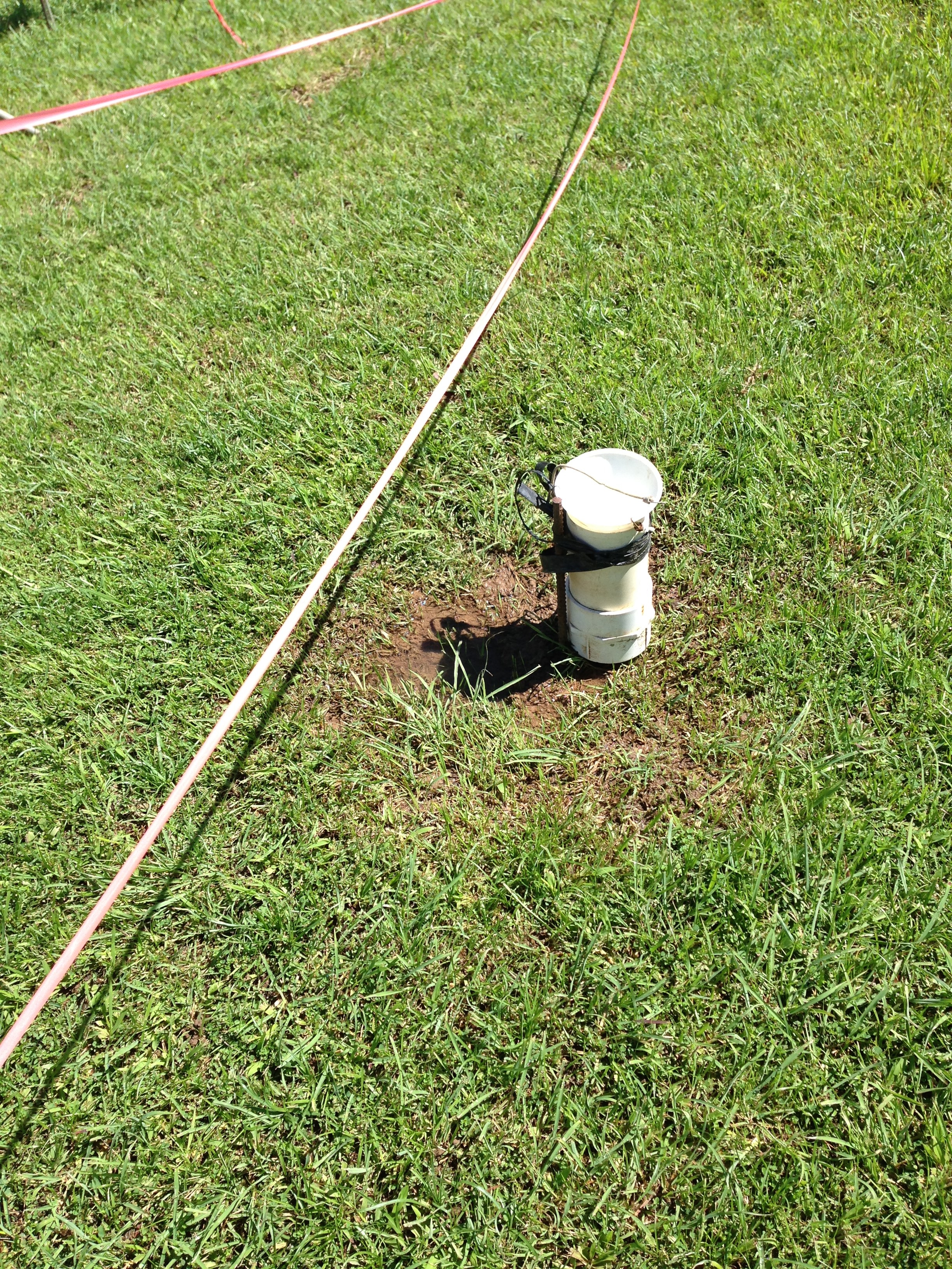
Here are two photos showing excessive trimming around my research equipment. The sensors are sensitive to the ground cover, especially the net radiation sensor. Consequently the alteration of the site by trimming may compromise the integrity of the data collected by the instruments. The preferred situation is green grass that is 3 or 4 inches tall.
 Figure 1. Excessive trimming around the research equipment. To prevent further trimming within the area, the red construction tape was put up around the perimeter.
 Figure 2. Excessive trimming of grass is observable under the center net radiation sensor.
Here are some random pictures showing excessive trimming on the UPRM campus.


 This is a groundwater observation well. Notice that after it rains the depression fills with water. This water will result in excessive infiltration around the well, possible altering the measured aquifer water level and the water quality.

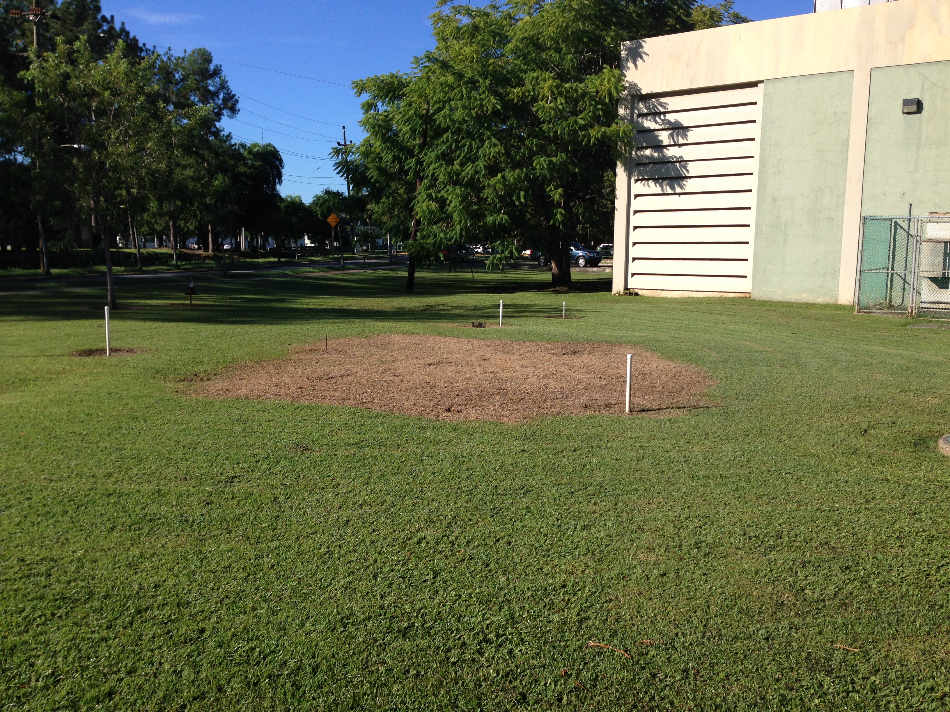
When I informed a couple of the worker about my concern, they agreed not to trim inside the perimeter of the area. But to fulfill their mission, they came back with some type of chemical (Roundup?) and sprayed everything within the perimeter!!!!!!!! OMG!!!! Please stop trying to help me! The two pictures below clearly show the grass dying within the area of the research equipment. It is possible that within a week there will only be brown dirt within the area, I hope not.


UPDATE: Here is three days after the above pictures were taken.


On October 28, after the weather station equipment had been removed, here is what the grass looks like.

The following links will provide guidance on scheduling irrigation using the ETo map data.
Harmsen E.W., 2012. TECHNICAL NOTE: A Simple Web-Based Method for Scheduling Irrigation in Puerto Rico. J. Agric. Univ. P.R. 96 (3-4) 2012.
Today a new weather station was installed in the Finca Alzamora, UPRM campus, Mayaguez Puerto Rico. Data from the weather station are available from two websites: WeatherLink or WeatherUnderground. The WeatherUnderground site allows you to download archived data in a coma delimited text format that can be imported into Excel. Data being collected include: air temperature, dew point temperature, RH, wind speed and direction, solar radiation, UV index, soil moisture tension and soil temperature. A value of the reference evapotranspiration is available on the WeatherLink page. We are still working out a few kinks, but should have it running smoothly within a few days.

The weather station was purchased with funds from the UPRM NOAA CREST Project.
The following links will provide guidance on scheduling irrigation using the ETo map data.
Harmsen E.W., 2012. TECHNICAL NOTE: A Simple Web-Based Method for Scheduling Irrigation in Puerto Rico. J. Agric. Univ. P.R. 96 (3-4) 2012.
Excellent article. Let’s get our priorities straight.
 http://www.africanglobe.net/wp-content/uploads/2014/04/School-Girls-Kidnapped-In-Nigeria-1.jpg
On a scale of one to ten, what is more horrible than the kidnapping of little girls to be sold into sexual slavery in order to scare folks into not sending girls to school?
How should we react to that? Is it as important as sanctioning a country for the invasion of another? Is it as important as searching for a plane that has disappeared at sea? Or rescuing miners trapped in a mine?
There are problems in the world that are important. Other problems that are urgent. The international community has to decide where to direct its focus, it’s condemnation and it’s resources. The press can either shine it’s light on festering wounds or create distractions.
Then there are problems that are BOTH hugely important and desperately urgent. So much so, that they merit the full weight of our attention. How long will we drift on the wings…
View original post 668 more words

