


Hourly and daily-integrated solar radiation data are available for download for U.S. Virgin Islands, Puerto Rico, Dominican Republic, Haiti, Jamaica and Cuba by clicking here. Examples of the daily integrated solar radiation data are given below.
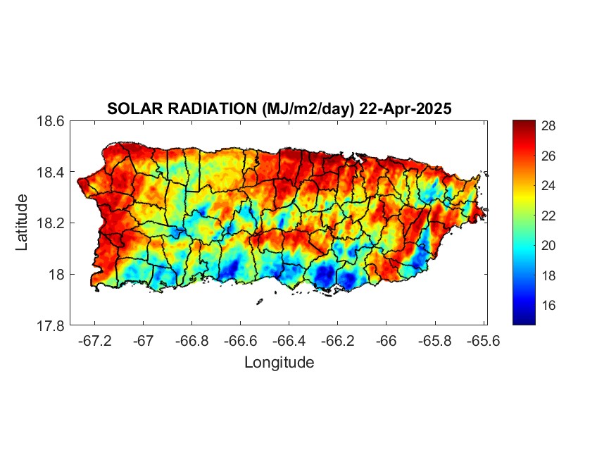
YESTERDAY’S SOLAR RADIATION DATA FOR PUERTO RICO
Characteristics of the Solar Radiation Data
Spatial resolution:
Puerto Rico, Culebra, Vieques and U.S. Virgin Islands 1-km
Puerto Rico, Dominican Republic, Haiti, Jamaica and Cuba 2-km
Range of data for 1-km dataset: March 2009 through present. The data set is not entirely complete. Technical problem prevented data from being collected between mid January through mid March 2011.
Range of data for 2-km dataset: Early March 2010 through present. The data set is not entirely complete. Technical problem prevented data from being collected between mid January through mid March 2011.
Format of data files: The name of the data file indicates where the data is from. RICO signifies Puerto Rico, Culebra, Vieques and U.S. Virgin Islands. CARIB signifies Puerto Rico, Dominican Republic, Haiti, Jamaica and Cuba. Also given in the file name is the julian day and year. For example, 2010079, indicated the year 2010, julian day 79. The extension on the file is .gz, which can be unzipped with any compression software such as WinZip or or 7-Zip and can be downloaded at the following site http://www.filehippo.com .
The unzipped file is a text file. If the file is imported into an Excel spreadsheet, you will see three columns of data: column 1 is solar radiation in units of megajoules per square meter per day x 100, column 2 is latitude north and column 3 is longitude west. To obtain the solar radiation in megajoules per square meter per day, simply divide the value by 100.
DOWNLOAD SOLAR RADIATION DATA HERE
Archived Daily Solar Radiation Images for Puerto Rico
Archived Monthly Average Solar Radiation Images for Puerto Rico
Archived Annual Average Solar Radiation Images for Puerto Rico (2009 through 2015)
Remote Sensing Calibration: Harmsen et al. (2014) conducted a calibration and validation of the satellite remote sensing product. The study resulted in the following conclusions (direct quotation):
“In this study, pyranometers at Fortuna and UPRM were re-calibrated. Using the re-calibrated pyranometers, solar radiation data from a GDM satellite remote sensing method was calibrated. For the daily-integrated analysis, R2 values for the linear equations, for Fortuna and UPRM were 0.88 and 0.83, respectively. The R2 value for the combined data equation was 0.87. A validation was conducted for a 283-day period for Fortuna and a 226-day period for UPRM. The site-specific equations [equations (5) and (6)] performed well, however, when using the combined data equation [equation (9)], solar radiation was underestimated consistently by 1 or 2 MJ/m2/day on average for Fortuna. On the other hand, the same equation performed well for Mayaguez (MBE = –0.11 MJ/m2day, RMSE = 1.79 MJ/m2day and % error = –0.56). The uncorrected data produced reasonably accurate results at both locations with a maximum % error of 6.22%, which is comparable with estimates obtained in the literature. Therefore, the uncorrected remotely sensed solar radiation data are recommended for use throughout Puerto Rico. This study did not consider areas of the island defined as humid-mountainous, and therefore, future calibration/validation efforts should focus on this environment. This research should be considered preliminary, as ongoing efforts are underway to further improve the accuracy of the remote sensing product in Puerto Rico.”
Harmsen, E.W., P. Tosado and J. Mecikalski, 2014. Calibration of Selected Pyranometers and Satellite Derived Solar Radiation in Puerto Rico. Int. J. Renewable Energy Technology, 5(1):43-54.
Definitions of terms in the above paragraph: Fortuna is located at the University of Puerto Rico Agricultural Experiment Station near Juana Diaz, PR. UPRM is the University of Puerto Rico-Mayaguez Campus. GDM stands for Gautier, Diak, and Masse, the original developers of the solar radiation estimation procedure. R2 stands for R squared or the coefficient of determination. MBE is mean bias error, and RMSE is the root mean squared error.
DISCLAIMER: The information is provided “as is”. The authors and publishers of this information disclaim any loss or liability, either directly or indirectly as a consequence of applying the information provided herein, or in regard to the use and application of said information. No guarantee is given, either expressed or implied, in regard to the accuracy, or acceptability of the information.
Acknowledgement: I would like to thank Dr. John Mecikalski for extending the GDM GOES-based solar radiation model to include Puerto Rico, Hispaniola, Jamaica and Cuba. Dr. Mecikalski is an Associate Professor in the Department of Atmospheric Sciences, University of Alabama in Huntsville (UAH). He also conducts research for the National Space Science and Technology Center (NSSTC). Email: johnm@nsstc.uah.edu
Some Applications of Remotely Sensed Solar Radiation
Otkin, A. J., M. C. Anerso, J. R. Mecikalski and G. R. Diak, 2005. Validation of GOES-Based Insolation Estimates Using Data from the U.S. Climate Reference Network. J. of Hydrometeorology, Vol. 6, August:460-475.
Harmsen, E. W., J. Mecikalski, A. Mercado and P. Tosado Cruz, 2010. Estimating evapotranspiration in the Caribbean Region using satellite remote sensing. Proceedings of the AWRA Summer Specialty Conference, Tropical Hydrology and Sustainable Water Resources in a Changing Climate. San Juan, Puerto Rico. August 30-September 1, 2010.
Harmsen E. W., J. Mecikalski, P. Tosado Cruz and Ariel Mercado Vargas, 2010. Estimating Evapotranspiration using Satellite Remote Sensing in Puerto Rico, Haiti and the Dominican Republic. PowerPoint Presention given at the 46th Annual Meeting of the Caribbean Food Crops Society, July 12, 2010, Boca Chica, Dominican Republic
Harmsen, E. W., J. Mecikalski, M. J. Cardona-Soto, A. Rojas Gonzalez and R. Vasquez, 2009. Estimating daily evapotranspiration in Puerto Rico using satellite remote sensing. WSEAS Transactions on Environment and Development. Vol. 6(5):456-465.
Banner image by http://commons.wikimedia.org/wiki/File:Solar_panels_in_Ogiinuur.jpg
Follow @pragwater
Still having some problems with the data, related to the tornadoes last week in Alabama. The computers went down at the University of Alabama-Huntsville on April 27th. A solar radiation data set was produced on May 5th, however, Dr. John Mecikalski has informed me that that data set appears to be mixed with the previous day and should probably not be used. May 6th no data. Today, May 7th we have a data set. Lets hope they keep coming.
Eric
I just noticed that the solar radiation data has not appeared since July 11th. My apologies, I am trying to correct this problem. I will send another post when it is back online.
Eric
Server still down. Hopefully we can recover the missing data at some point in the future. The GOES satellite sent the raw data and it is recorded on some server somewhere. However, I have been told that the NASA people are working to upgrade the server we use to process the solar radiation data. I will send another post as soon as I hear something.
Eric
Solar radiation data is back online. Sorry for the inconvenience.
Eric
See new post on GOES-Puerto Rico Water and Energy Balance (GOES-PRWEB) algorithm: https://pragwater.wordpress.com/goes-puerto-rico-water-and-energy-balance-goes-web-algorithm/
Eric
I downloaded the Puerto Rico solar insolation for julian day 1, 2011 and I was wondering how do I interpret the lat and long points that have data -9999 MJ m-2 d-1… Do you have available estimated annual average for Puerto Rico?
–Bali
Dear Braulio,
The -9999 can mean two things. I looked at the INSOLRICO and INSOLCARB files for 1/1/2011 and all values were -9999. In this case it indicates that the solar insolation algorithm could not produce any results, perhaps because the GOES satellite sensors were offline. Alternatively, in the INSOLCARB file some of the outlying coordinates are always assigned -9999 values, since these coordinates are outside of our area of interest. The active area (non -9999) in the INSOLCARB file extends from the USVI to western Cuba, and from below Jamaica to above the top of Cuba. Unfortunately Braulio, the 1/1/2011 file was not a good one to start with. Please take a look at the files for 1/2/2011.
Another problem, more common than the one you identified in the 1/1/2011 file, is when the file for a given date is not produced at all. When this happens, you will typically see missing files for a few consecutive days. However, there was a long period when the algorithm server was down from julian day 13 to day 77 in 2011.
You mentioned that the data are in units of MJ m-2 d-1, this is not correct. The units are (MJ m-2 d-1) x 100. This form of insolation was used in order to be able to use an integer format. To obtain the data in MJ m-2 d-1 (real format) divide the file value by 100.
The annual average daily solar radiation for Puerto Rico for 2010 can be seen at the following link: http://dl.dropbox.com/u/4369968/INSOL.jpg
Eric
Pingback: What are People doing with the Northern Caribbean Solar Radiation Data – Unedited list (March-December 2011) | PRAGWATER
We are having trouble with the solar data. The 2-km northern Caribbean data has not appeared since December 27 and the 1-km PR data stopped on December 29. Dr. Mecikalski is investigating the problem. Sorry for the inconvenience,
Thanks John, everything appears to be working well. The solar data is downloading to the FTP site as it should. – Eric
Pingback: On Reading Old Things | PRAGWATER
Hello, Curious, are you aware of potential large scale solar projects being attempted in Haiti? 100 MW in PaP and +/- 10 MW in Cap Haitien being researched by USAID? May you have any additional information on these proposals? Thank you, whv
Bill,
Sorry but I don’t have any information regarding large solar projects in Haiti. Good luck with your investigation.
Eric
I would like to encourage the visitors to pragwater to address Bill’s question. Many of the request forms for insolation data that I receive do indicate that they are for PV projects in Haiti, but very few details are provided.
Pingback: Ubiquitous Energy: A Solar Game-Changer? | PRAGWATER
Monthly average solar radiation images for Puerto Rico can be downloaded at the following link:
http://academic.uprm.edu/hdc/GOES-PRWEB_MONTHLY_RESULTS/solar_radiation/
The images includes 26 months of data starting in January 2010.
Other atmospheric/hydrologic data images are also available at the following link:
https://pragwater.com/goes-puerto-rico-water-and-energy-balance-goes-web-algorithm/
Hi, I am having a slight problem.. I am desparately trying to get hourly solar radiation data for jamaica.. i have unzipped the file and i do have micrsoft excel.. however it is not recignizing the file.. it gives me the error “invalid win32 application” could you assist?
figured it out…
how do i interpret it now?
Miss-jj, Here is how you can interpret the hourly data:
Rows 1 and 2, Column A and B. These are headers for the latitude (XLAT) and longitude (XLON). You should re-adjust these rows so that the headers in column A line up over the first column of numbers.
The numbers to the right of the headers are the hours in Universal Time. For Puerto Rico for example, which is 4 hours behind Universal Time, the time 9:45 is actually 5:45 AM. (I am looking at file HOURLYCARB.2010072)
Unfortunately the numbers for all the hours don’t fit on a single line. 24 times fit on one row and 8 time (for the same day) appear on the next line.
What you will need to do is scroll down the page until you come to the XLAT and XLON for your location. Then read off the values of solar radiation to the right. Units for the hourly data are in Watts per square meters.
Let me know if you have any problems.
Eric
Weeeee, what a quick and easy sootiuln.
Pingback: DOWNLOAD HOURLY AND DAILY SOLAR RADIATION DATA FOR THE NORTHERN CARIBBEAN REGION. | PRAGWATER
Pingback: Solar data available for the northern Caribbean | PRAGWATER
Pingback: DOWNLOAD SOLAR DATA FOR PR, DR, USVI, HAITI, JAMAICA AND CUBA | PRAGWATER
Pingback: Replacement Weather Satellite for GOES East | PRAGWATER
Pingback: Good News!! GOES-13 is back online. Solar Radiation Data is Available For Downloading | PRAGWATER
Excellent!! Data at http://www.soils.wisc.edu have much less resolution…one request though… Could you make available the monthly insolation data for the Caribbean region? I can only find images from Puerto Rico.
Thanks for this website
Pedro,
Thanks for the comment. I take it you are interested in the high resolution IMAGES of solar radiation for the northern Caribbean? If it is the high resolution “data” you are interested in, this already exists at http://academic.uprm.edu/hdc/solar/. I don’t know when I will have time to develop an automated script for making the high res images, but I will definitely put that on my priority list.
Pingback: Solar Radiation Data Available for Northern Caribbean Region | PRAGWATER
Pingback: SOLAR ENERGY | PRAGWATER
The datasets provide valuable spatial data for analysis, but gaps in collection from January to March 2011 due to technical issues may affect temporal accuracy. File names include location codes (RICO/CARIB) and Julian dates, and are compressed in .gz format for efficient storage. These datasets help a lot in solar system designing and solar inverter sizing accordingly.